Southern Indiana Weather Spotter's Reference
Current Mesoscale Discussions for the USA

Checks for Severe Potential, Heavy Rain, Heavy Snow, and Freezing Rain
Note: This page will reload every 2 minutes. Mesoscale Discussions are listed in the order issued.
Click on the MORE link below to view further details of the SPC Mesoscale Discussions.

MESOSCALE DISCUSSION 0664
NWS Storm Prediction Center Norman OK
0800 PM CDT Mon May 06 2024

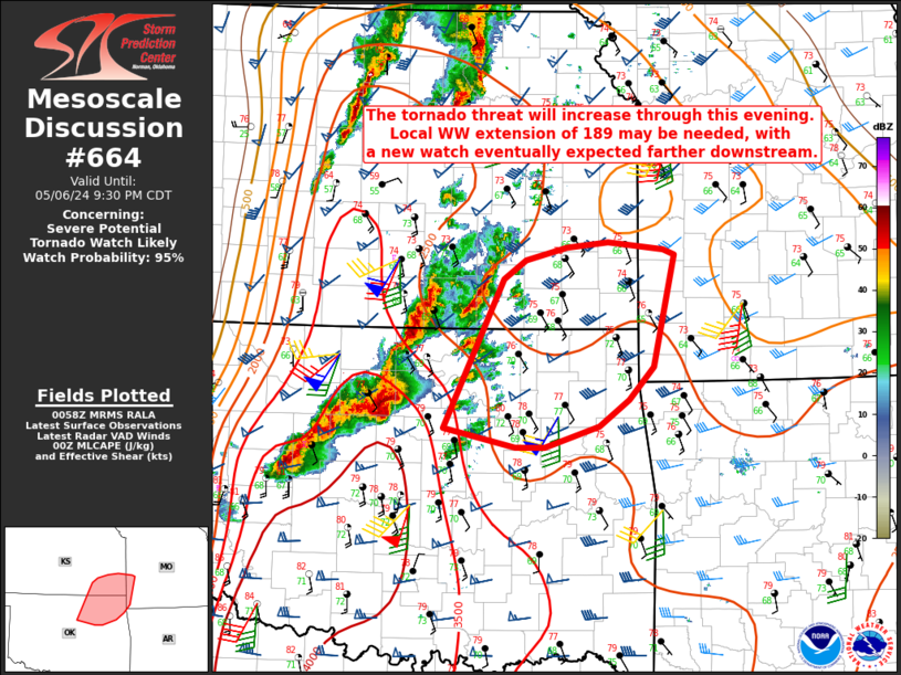
AREAS AFFECTED...Northeast OK into southeast KS and extreme
southwest MO

CONCERNING...Severe potential...Tornado Watch likely

VALID 070100Z - 070230Z

PROBABILITY OF WATCH ISSUANCE...95 percent

SUMMARY
...The tornado threat will increase through the evening.
Local extension of WW 189 may be needed, with Tornado Watch issuance
eventually expected downstream.

DISCUSSION...Convective showers are beginning to increase from
central/northeast OK into southeast KS, ahead of the primary
corridor of supercells to the southwest. With a continued increase
of the low-level jet
....... more

MESOSCALE DISCUSSION 0662
NWS Storm Prediction Center Norman OK
0736 PM CDT Mon May 06 2024

AREAS AFFECTED...Northwest and west-central Missouri

CONCERNING...Severe potential...Tornado Watch likely

VALID 070036Z - 070230Z

PROBABILITY OF WATCH ISSUANCE...95 percent

SUMMARY
...A tornado watch will likely be needed this evening as
storms move into western portions of Missouri. QLCS TORNADOES and
DAMAGING WINDS are the expected primary hazards.

DISCUSSION...A linear segment east of Concordia, KS will continue
northeast this evening. This activity may reach northwest Missouri
between 8:30-9 PM CDT based on current projections. As upper-level
forcing continues to
....... more