| Severe Weather Jumpstart |
| Starting Out The Day |
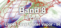
Water Vapor Satellite:
GOES East
Upper Level Water Vapor
|
Water vapor satellite imagery reveals the atmosphere in motion including the jet stream (extended dark regions)
and tropical moisture transport, represented by the cooler areas (white and green).
Moisture laden air can produce significant precipitation events and fuel thunderstorms when advected into a storm system.
|
Weather Summary:
WSFO Paducah
|
Want to know what has happened through the night? Here is where to find
out! This product is issued twice daily, around 4:00 AM and 5:00 PM by WSFO Louisville
and Paducah. It is
a brief summary of the weather that has occurred statewide since the last issuance. |
Short Range Discussion:
Weather Prediction Center |
The short range meteorologist prepares forecasts for the continental U.S. using numerical model output from available forecast models.
Discussions are written on each shift and issued at 0900Z and 2100Z
highlighting the reasoning behind the forecasts and significant U.S. weather. |
Convective Outlook:
Storm Prediction Center |
Just getting your morning cup of coffee? If so, here is a good place to start
the day. The SPC in Norman, Oklahoma works through the night and
issues this product beginning at 06Z (1 AM EST) to outline areas in the continental
United States where severe thunderstorms
may develop over the next 6 to 30 hours. Your local forecast office pays close attention to
the SPC's guidance, which is updated at 13Z, 20Z, and 01Z. |
Hazardous Weather Outlook:
WSFO Paducah
WSFO Louisville
WSFO Indianapolis
|
Wonder what is on the horizon in terms of locally severe weather and
whether spotter activation will be needed? Then check out the
Hazardous Weather Outlook which is issued by your local forecast office at least once daily by around 5 AM EST/EDT and
is updated as needed. The HWO highlights any expected hazardous weather conditions over the next seven days!
|
Local Discussion:
WSFO Louisville
WSFO Indianapolis
WSFO Paducah |
When severe weather is headed your way, the forecaster at your local WFO
begins the day be checking computer models to see what they
predict. He also takes a look at
the SPC's Day One Convective and uses his expertise to generate
the local forecast. What is his thinking when he does this? Here is where you can find out! |
Thunderstorms Probability:
The Weather Channel
The Storm Prediction Center |
Here are very informative US maps
which depicts areas of the Country which may experience either
Strong or Severe Thunderstorms. Look here to see whether your area may be affected. |
| As The Day Progresses..... |
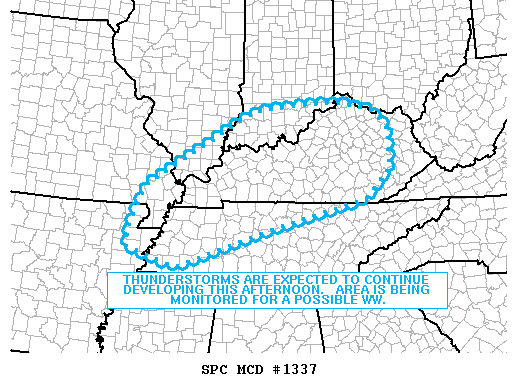
Mesoscale Discussion:
Storm Prediction Center |
When conditions actually begin to shape up for severe weather, the SPC often issues
a Mesoscale Discussion (MCD) statement ANYWHERE FROM ROUGHLY HALF AN HOUR TO SEVERAL HOURS
BEFORE ISSUING A WEATHER WATCH. The MCD basically describes what is currently happening,
what is expected in the next few hours, and when/where the SPC plans to issue the watch (if any).
MCDs can help you get A LITTLE EXTRA LEAD TIME on the weather and allow you to begin gearing
up operations before a watch is issued. |
Public Severe Outlook:
Storm Prediction Center |
This product is only issued by the SPC on an as needed basis. When it appears,
LOOK OUT! Something significant, weather wise, is probably going to transpire later
in the day. The report is very useful in noting just what that might be as well as pointing our the
affected areas.
CHECK THE DATE ON THIS ISSUANCE! The last one issued stays put
till a new one is released so you might be looking at old data. |
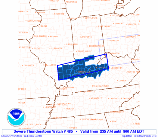
Weather Watches:
Storm Prediction Center |
When conditions are favorable for severe thunderstorms and tornadoes to develop,
the SPC usually issues a severe thunderstorm watch or a tornado watch. When the SPC feels confident
about the possibility of severe weather in a specific area, they try to issue a watch at least 30 minutes prior the onset of severe weather. |